Broken Bay
Grade 4: Recent research raises some questions about the whereabouts of Cook’s Broken Bay, long believed to have been at Narrabeen Lagoon. Both sites are worth visiting. The entrance to today’s Broken Bay can be viewed to advantage from Barrenjoey Lighthouse, and still retains much the same appearance it would have had in 1770. Narrabeen Lagoon is perhaps best viewed from the dunes south of the lagoon outlet below Narrabeen Head.
Situation: Sydney’s northern beaches. Narrabeen, and beyond Palm Beach.
Coordinates (decimal):
Narrabeen Lagoon (Cook’s Broken Bay): 33.71 S 151.29 E
Today’s Broken Bay: 33.65 S 151.22 E
Endeavour Journal, 7 May 1770:
At sunset the Northernmost land in sight bore N 26 E [apparently the area between today’s Broken Bay and Cape Three Points] and some broken land that appeared to form a bay bore N 40 W distant 4 leagues [more than 22km]. This bay I named Broken Bay, Latitude 33 36 S.
On today’s maps Broken Bay lies beyond the northern beaches suburbs of Sydney, Australia, at the entrance to the Hawkesbury River, and south of Cook’s Cape Three Points. But is this the feature Lt James Cook named in 1770? It seems very unlikely. When Governor Arthur Phillip’s party reached this bay in small boats in March 1788, they assumed this was what Cook had seen and named, and the name has stuck. Matthew Flinders realised that Cook had placed the bay further south and concluded that he had named the area near today’s Narrabeen Lagoon. From his vantage point out at sea Cook would not have observed the low lying sand dunes that separated the lagoon from the sea, and assumed that he was viewing a bay entrance. Sailing close to the shore, Phillip’s party would have passed these dunes and would naturally have assumed that the first bay they came upon soon after was what Cook had named.
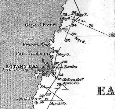
Cook had viewed his Broken Bay at sunset and from some distance to the south. He would have passed Governor Phillip’s Broken Bay during the night. However, a few days later having been ‘taken aback’ by adverse winds and currents he found himself just to the north of, and close to, Phillip’s Broken Bay (see charts below). In the afternoon of 10 May Cook was very close to Cape Three Points’ Third Point and appears to have charted the reefs shown on Stokes’ chart as West and East Reef. The soundings on Stokes’ chart correspond closely with Cook’s 23 fathom sounding. It seems surprising that he did not record seeing the entrance to today’s Broken Bay. Strangely, in the Endeavour Journal Cook records two different latitudes for his Broken Bay. At first he records it at 33.36 S and later (in the copy of the Journal submitted to the Admiralty on completion of the voyage) at 33.42 S. 33.36 S is close to the latitude of Phillip’s bay, while 33.42 S is close to Narrabeen Lagoon. On his chart he shows Broken Bay in this latitude.
A reduction of Captain Cook’s original chart of the east Australian coast line 1770 from originals in British Museum, South Sheet (part). State Library of Victoria, MAPS 805.8 AJ 1770-1890. This chart shows Cook’s Broken Bay in the latitude of today’s Narabeen Lagoon.
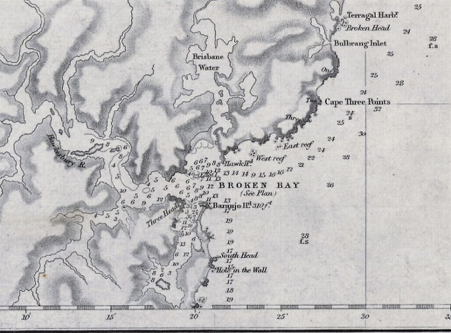
Broken Bay and Cape Three Points. John Lort Stokes’ 1852 Chart, Australia East Coast, Sheet IV, Broken Bay to Sugarloaf Point (part). National Library of Australia, nla obj-233813814. Narrabeen Lagoon is off this chart, just to the south. This chart shows the position of Cook’s Broken Bay as determined by Governor Arthur Phillip in 1788, and as it appears on today’s maps and charts.
There is a remarkable similarity between the entrances and distant hills at today’s Broken Bay and Narrabeen Lagoon as shown in two watercolours made in 1818. The dunes at Narrabeen Lagoon today appear to be much higher than they were at that time. It is easy to see that from out of sea the sand dunes would not have been visible to Cook.
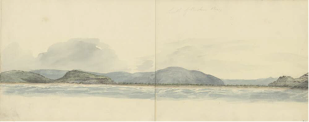
South of Broken Bay, New South Wales, ca. 1818 by Edward Close (Narrabeen Lagoon area), National Library of Australia, NLA obj-138901461
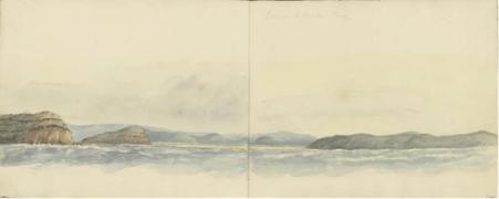
Entrance to Broken Bay, New South Wales, ca. 1818 by Edward Close, National Library of Australia, NLA obj-138901769
It seems most likely that what Cook saw and named as Broken Bay was Narrabeen Lagoon. However the two latitudes he gives and his proximity to today’s Broken Bay on 10 May 1770 raises questions that are unlikely ever to be answered.
References:
Trevor Lipscombe, ‘Broken Bay – the mystery of Cook’s two latitudes’, Cook’s Log, Vol.41, No.4, October-December 2018. ‘Lt James Cook’s Broken Bay’, Map Matters 34, August 2018 (http://www.australiaonthemap.org.au/wp-content/uploads/Map_Matters_34.pdf)